
Naru Shiode from the University at Buffalo gave a spellbinding presentation on spatial-temporal analysis at the Centre for Spatial Analysis (CSpA) on Friday. 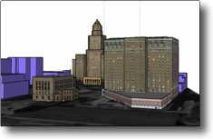 Shiode is trained as architect and urban planner and finds himself in the Geography department at Buffalo. He has been associated with projects such as Digital Egypt and the Virtual Ryoanji projects exploring ancient historical reconstruction as well as time-based recremorphing. His current project is the 3D Buffalo project which allows a user to interact via a chronoslider that triggers time points for each building within a multi-block area surrounding downtown Buffalo. This project is only in its early stages, but the potential for historical analysis is tremendously promising.
What Shiode and his co-PI are doing is exploring a similar spatial-temporal linkage that I have been doing my individual best to create create on a smaller scale for Guelph. Unlike my attempts to attach a 3D streetscape from Guelph to census, tax and business directories and ultimately to the inhabitants through their physical surroundings, Shiode is very much concerned with wedding CAD and GIS to focus on the aesthetics of the built environment. The result of his work is most impressive. The interface employs a chronologically structured slider which ties to buildings categorized by their period of existence so that as you slide, they are erected in realtime. The 3d mass models have had surfaces mapped from historical and contemporary photographs and are superimposed on aerial photos to provide streetscape.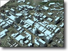
Of note is that the use of aerial photography to establish buildings and to use as the underlying backdrop for the model itself. Shiode points out the challenge this poses with street reorientation over their period of study.
Shiode asks three prescient questions of his own current work:
- How do we choose to visualize uncertain data? While he offers some answer to this, I think that it probably depends on the context of the analysis that we are trying to do and the level of inference that we feel comfortable to exercise;
- How can we continue to make the data and the tools compatible? They’ve done a great job harmonizing GIS and CAD.
- How do we harness the power of a dynamic 3D model?
Great questions that anyone playing in this arena inevitably faces.
Projects such as Rome Reborn1.0 (which I blogged on earlier this year) have focussed on similar aesthetic recreation of the visual. One of the future directions for Rome is to consider the audible end of the equation (I suppose smell might even be there someday). The absence of people in many of these models seems to be the biggest gap. We are studying them through their material artefact, yet don’t represent them as part of the model. The choice to include the human dimension depends on what the model is being constructed to explore or accomplish. Thus the third and most prescient question above.
The challenge in asking this question is that in many cases, it is only through construction that we discover some of the questions that can be asked or patterns that might be discovered. Questions leading to the development of the model often lead to begging the bigger questions to ask of the model. Spatial-temporal modeling simply presents existing data in a different way and allows for the viewer/participant to see patterns that aren’t otherwise apparent. 3D Buffalo looks like it will have tremendous potential for deeper understanding of early twentieth century urban development.