It feels as though I have been there many times – wandering through rural Lesotho. Traversing table mountains, dramatic escarpments, moving from small hamlets and villages following winding rivers fed by meandering streams. When I want to travel I choose 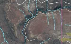 a task in OpenStreetMap and am transported to somewhere in rural Lesotho. I trace streams, identify residences, farms, commercial areas, and industries and in so doing meet the landscape, built and natural with great intimacy. I have developed a unique attachment through this virtual tourism. The amount of verdant, stream dominated, green areas continues to amaze me when I realise that Lesotho is a country where all the land is more than 1000 feet above sea level. It’s marvelously diverse and changes from what seems to be semi-fertile tillable areas to steep cliff faces within short distances. Appreciating it from this unique and privileged perspective only drives a deep desire to see the land in person. The wider purpose in what I do though is to contribute, along with hundreds of others, to create open and publicly usable maps that are available for the benefit of the citizens of Lesotho and the wide world. You meet fellow mappers in Ireland, Lesotho and around the world – virtually and face-to-face. It’s a splendid mission, socially rewarding and one that I find fun, wonderfully gratifying and full of future promise.
a task in OpenStreetMap and am transported to somewhere in rural Lesotho. I trace streams, identify residences, farms, commercial areas, and industries and in so doing meet the landscape, built and natural with great intimacy. I have developed a unique attachment through this virtual tourism. The amount of verdant, stream dominated, green areas continues to amaze me when I realise that Lesotho is a country where all the land is more than 1000 feet above sea level. It’s marvelously diverse and changes from what seems to be semi-fertile tillable areas to steep cliff faces within short distances. Appreciating it from this unique and privileged perspective only drives a deep desire to see the land in person. The wider purpose in what I do though is to contribute, along with hundreds of others, to create open and publicly usable maps that are available for the benefit of the citizens of Lesotho and the wide world. You meet fellow mappers in Ireland, Lesotho and around the world – virtually and face-to-face. It’s a splendid mission, socially rewarding and one that I find fun, wonderfully gratifying and full of future promise.
A few months go I caught passing glance of a tweet mentioning a mapathon to be held at the Fingal County Council offices in Swords. Of curiosity, I signed up and turned out to be part of a day-long push along with mappers in a variety of other locales to spur the creation of first-pass basemaps that will be refined through collective dedication. Why do I continue to do it? I love maps and I love feeling that I am putting my own skills to use that contributes to a greater whole. As we watch the progress (and as a group, we have now passed the 75% in the rural tasks) that magic 100% will mean that local mappers can refine the rudimentary based on their local knowledge.
MapLesotho is a global initiative that demonstrates an emerging ethos of social crowdsourcing that truly benefits all participants – each and every drawing from the experience rewards beyond their own contributions.
[…] Posted on 19 December 2014: on Shawn Day’s blog It feels as thought I have been there many times — wandering […]