
 Anxious to participate in the crowdsourced initiative to map out Ireland’s historical political and administrative boundaries, I have been carefully and steadily following the stages outlined by Dave Corley in “Mapping Irish Townlands”. As I mentioned last week he has provided superb resources and the project itself is to my mind a very noble one. I spoke about it Challenging the Spatial Historian.
My involvement with OpenStreetMap (openstreetmap.org) over the past few years has been in choosing places that I was associated with and adding missing features identified either from memory or suggestion by the satellite imagery provided. The process of tracing features from satellite imagery is strangely soothing. I suppose it is rather like real life Minecraft and I feel somehow gratified for effort extended and feel that I m contributing to a good cause. In most recent times much of this effort has been contributed to Mapping Lesotho (http://maplesotho.wordpress.com) – an initiative led out of Fingal County Council in cooperation with a variety of public and private groups in Lesotho. Progress on this project has been impressive amongst a wide group of contributors and most recently there is lovely post by Colin Broderick (http://maplesotho.wordpress.com/2014/10/12/maplesotho-edits-jan-oct-14/) that visually demonstrating this progress.
Joining into the the Irish Boundaries Mapping initiative is a major rachetting up on the necessary skills and the variety of tools employed. As I mentioned previously in Challenging the Spatial Historian there is serious work/effort involved and I have found the upskilling a challenge. This is a good thing!
Measurement of Progress
Overall progress in the Irish Townlands project is measured and displayed in two places:
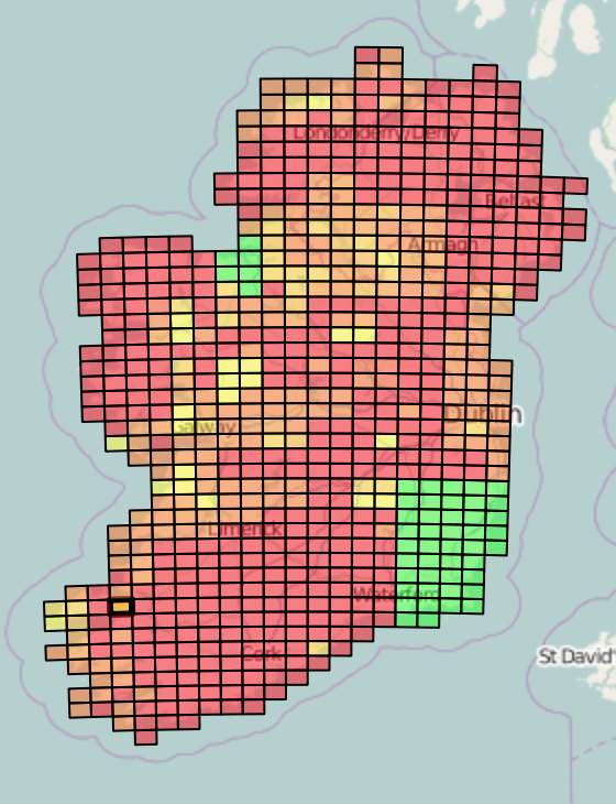
MapCraft (http://mapcraft.nanodesu.ru/pie/307) and the Irish Traditional Boundaries website (http://www.townlands.ie/progress/). The website is clean and particularly well implemented. It is presented in a simple and straightforward manner and a great example of how to do so. Mapcraft (http://wiki.openstreetmap.org/wiki/MapCraft) is a tool new to me. It’s a collaborative tool specific to OpenStreetMap and designed to coordinate efforts towards a specific project.
Progress in the ITB project is still in its early stages as a quick glance at the MapCraft status shows us an awful lot of orange and red areas. Green means that the parish boundaries have been marked and are complete. Other colours indicate varying degrees of progress from Red indicating lack of progress to orange and yellow showing limited progress.
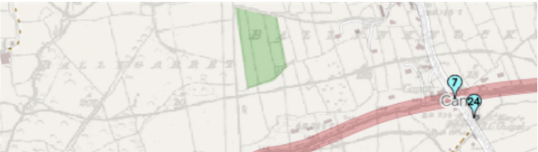
Consulting this map helps you determine where you may have an interest in participating, whether from a personal connection or simply identifying gaps and targeting your efforts on that basis. For the record my initial interest in this is to see parish boundaries mapped for the area in Kerry around Camp where my Irish ancestors left from. As it turns out this was a less than pragmatic choice as the next step demonstrates. On the other hand, you have to find your own motivation to participate and this was my initial one. On a larger level I think that making a freely usable boundary file available for research is crucial and of value.
After identifying an area that remains to be done the next step is to see if there is historical imagery available to allow you to trace out the parish boundaries. There’s two ways to go about this as well.
If you are in Mapcraft and choose a tile of interest, the properties palette gives an indication of past activity and will include a reference to a MapWarper (http://mapwarper.net) URL with a link to the rectified historical imagery.
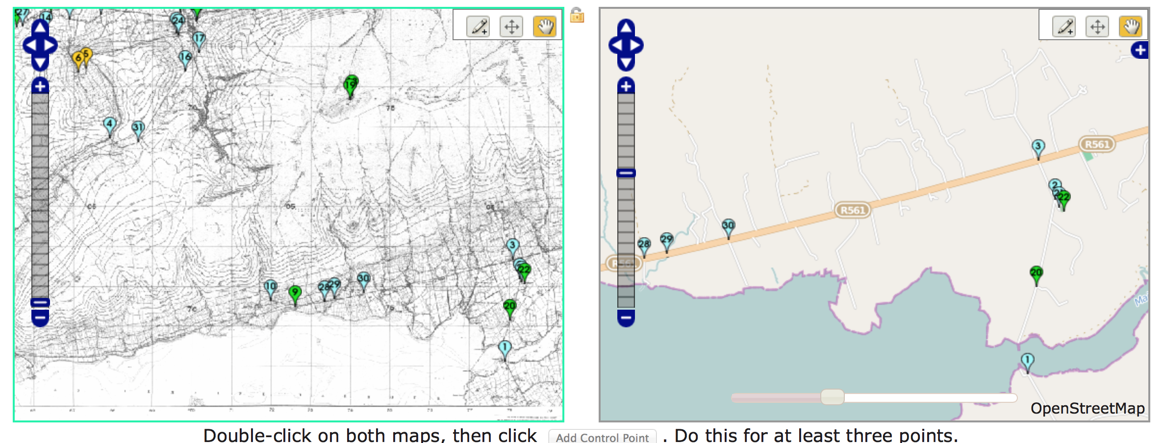
MapWarper is very cool and this is where the process starts to move beyond a beginner’s involvement with OpenStreetMap. This is a purely digital task. Through this rather cool rectification tool, the historical flat, paper map is stretched, bent and molded algorithmically to match up with the modern geographical data displayed in OpenStreetMap.
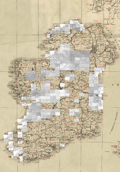
In the case of this project, a collection of complete imagery has been donated by Trinity College Dublin and as you can see the maps which have been rectified and supplied for use in your own mapping efforts and pasted onto this image:
If the historical imagery is not yet available you get to jump right into the community and make a request of the helpful folks in the background who can make missing imagery available. Details on this process are available here. I haven’t had to do this yet, as the imagery I was interested in has been made available, scanned and begun to be rectified. It is still in early stages and has not been fully rectified. Although this is a slightly subjective process, basically you need to find 60+ points on the historical map that you can match to current day features with certainty. Through the process you identify the matching feature with precision in MapWarper and indicate the two matching points. These are added to a rectification table and the server adjusts the imagery accordingly. When I started, there were 22 points mapped for the area of Kerry of interest. Immediately I realised why so few. The historical imagery is scanned at a very low quality (in fact the original is probably the culprit here) and this is combined with an area that is hilly/mountainous and devoid of specific features to aid in the mapping. I have found another 12 or so matching features thus far and work continues.
 However, immediately moving into rectification assumes another very important step and one that returns me to familiar territory – the availability of specific features in OpenStreetMap. I returned from my initial foray into inspecting the historical imagery to refine the existing features for the area. This geographic area has been only lightly touched in OSM, so I set to work beginning to trace features from the satellite imagery and to commit it to the OSM servers. This enhances it for everyone and specifically will aid in the rectification process. Rather than taking an all-in approach and mapping everything, in the current exercise there is prioritisation given to features that will aid me in the rectification process and this is where one has to think a little about what features will stand the test of a hundred years or so. Manmade things change and are fluid and even natural features are subject to the effects of erosion, and even seasons. Bearing in mind historical processes such as the building and removal of railways, farming practises such as field consolidation or drainage improvements all will shift features, but some will remain and give great clues to help match the historical with the current day map.
One tends to turn to specific individual techniques in practise of rectification. One I have jumped to for example could be cemeteries. Although not flawless, as they do shift, close and open, and boundaries are not always accurately mapped, but I work under a bit of an appreciation that hallowed ground tends to be respected so even on closing they generally remain untouched and often identifiable. So searching reveals a few of these. Churches also tend to have a degree of longevity – again not flawless, but at least suggestive. Larger infrastructure projects such as railway bridges and trackbeds are also good as Dave indicates and demonstrates in his videos.
So one patiently starts to work back and forth with these new tools, MapWarper for rectification, Mapcraft to see progress, communicate and indicate your own work and the OSM editor of your choice to add features that then appear to aid the entire process …. and I have not yet begun to even consider tracing townland boundaries, but that will come in time.
The learning thus far in moving towards mapping Irish Townlands boundaries is patience and studios attention to preparing all the right pieces. Making sure that the modern day features are comprehensively mapped so that we can apply good historical thinking to match these to historical imagery through the process of rectification. This will eventually provide historical guides to start to map the traditional Irish boundaries.
- Ireland/Mapping Townlands (http://wiki.openstreetmap.org/wiki/Ireland/Mapping_Townlands)
- Traditional Irish Boundaries Progress (http://www.townlands.ie/progress/)
- MapCraft (http://wiki.openstreetmap.org/wiki/MapCraft)
- MapWarper (http://mapwarper.net)