 I have great respect for the Programming Historian, a collaborative and evolving collection of tutorials and hands-on guides to inspire and guide practitioners in the art of doing digital history. The site does’t sugarcoat the one critical aspect of doing digital history: it requires dedication to learn and to carry out the programmatic end. It’s hard work. As one who tends towards the spatial rather than the textual end of the digital history spectrum (yeah, there’s probably autism in that) a project that I have recently encountered and am in the process of mobilising behind is the Irish Traditional Boundaries Open Street Map Project. One of the drivers behind the project is Dave Corley, a colleague with whom I have shared a few mapathons lately. When the opportunity to carry out an activity that enables better digital history and also shares an ethical approach to open research emerges … I get enthused!
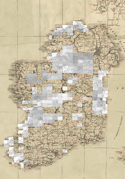
Mapping Irish Townlands is a crowdsourced project to generate a free to use spatial dataset for scholars and the wider public. It seeks to capture downland, and parish boundary at a so that it can be made available to anyone with a desire to use it. Until now, historical boundary data only been available through a paid license with the Ordnance Survey of Ireland. Costs prohibitive to use by individual scholars and certainly an insurmountable barrier for casual speculative discovery. For example, a year or so ago I wanted to consider new ways of seeing pattern of migration from Ireland during the Famine. I was able to obtain raw data, but seeking to visualise it I was stymied lacking boundary files with more granularity than county level for Ireland. I know the files exist and can actually browse them on the OSI site, but it stops there. What this project proposes to do is to combine the voluntary efforts of dedicated volunteer mappers throughout Ireland and around the world, provide them with rectified historical imagery donated by Trinity College Dublin and generate the boundary files that would benefit spatial historians like me.
But getting there involves my diligent efforts as part of this project and in honesty it’s a challenge. Having contributed to OpenStreetMap initiatives such as MapLesotho most recently and carried out mapping of a variety of locales in ireland and Canada, I have merely scratched the surface of appreciating the necessary skills in caring out digital cartography. Thankfully Dave and the team have created a series of helpful video tutorials to help the uninitiated such as myself gain these skills. Exciting hands-on challenge actually an one that I believe begs attention in the classroom and worthy of embrace by anyone who wants to further the OpenResearch agenda – especially in Ireland.
[…] to both so that once ‘warped’ or ‘stretched, bent and molded algorithmically’, as Shawn Day explains it, the flat, printed map image matches the coordinate system of the online digital map. […]