
Eric Fischer has posted a new series of visualisations ‘Locals and Tourists‘ depicting the location of photos taken in urban areas around the world. In this 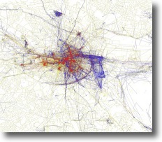 series he attempts to distinguish between those taken by tourists (people who seem to be a local of a different city and who took pictures in this city for less than a month) and those by locals (people who have taken pictures in this city dated over a range of a month or more). Intriguing.
What immediately struck me was his ingenious re-use of the existing data to create new information. By exploring individuals posted pictures over time he was able to hypothesise as to whether they were visiting or residing in a particular area. This allowed for a means to compare the gaze of the two groups.
I immediately started to explore his map of Dublin to see if any patterns emerged and then to try and suggest explanations for them. There is a healthy and regular mix of photos by both groups in the central core, but immediately to the east is a large blue box of photos taken by locals. It appears to surround the new Aviva Lansdowne Stadium in Ballsbridge. Additionally on the northside the National Botanical Gardens have a heavy concentration of photographs by locals.
The most practical application of Locals versus tourists is to consider how a visitor might use these visualisations to find the hidden city known only to its inhabitants – to find those secret spots worthy of capture by locals, but seemingly missed in the tourist guides.
This set builds on his earlier work ‘The Geotaggers’ World Atlas‘ looking at from where the pictures were taken, whether from car, bicyle or when walking.