
Today’s gadget du jour is the Royaltek RGM-3800 GPS Receiver and 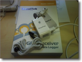 Datalogger. I have long wanted to experiment with one of these and today one arrived in the post from the UK. It’s a small ticket item (€50), but after a short test here I am very, very impressed. A GPS datalogger is just like your fancy GPS car receiver that projects your track on an LCD screen with the difference being, there’s no screen, and it simply records your position to flash memory at regular intervals. You can then download the datafile to your computer and plot the data on a map using google maps or similar.
It arrived this morning and I popped the batteries into it. It’s not much of a test as I sit here in the office, but Matt had to go out to run some errands and I asked if he would take it with him. I installed the software (Windows only unfortunately – Parallels to the rescue). The install was smooth and the device was recognized immediately. I access it and changed to logging interval to 15 seconds. The device itself is about half the size of a current mobile phone. It is powered by two AA batteries which supposed allow it to fill the memory a few times.
So Matt wandered off a hour ago and I he reports that the device did a cold start out in front of our office in 30 seconds and that the light remained solid for the bulk of his journey. When he returned to the office he handed me the device and I said well, we’ll see where you have been. I connected the supplied USB cable and started the data logger tool. It reported that the device 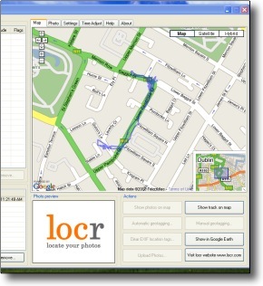 was operating (and had maintained contact inside our office here – I guess our window is large enough). All I had to do was click to send the data file (tagged with date and time) to an NMEA folder on my drive. It immediately showed up in a Google map window as part of the application. Plug and play indeed – colour me impressed.
We looked at the path plotted on the map and he confirmed that it was surprisingly accurate. It appears that the first few readings as it was getting a first fix were a little off, but it quickly got a decent accuracy. It actually seems to have tracked him crossing Pembroke to visit the ATM at the Ulster Bank and when he went inside and to the counter at the pharmacy around the corner. He spent about 45 minutes in the Grafton Barber and it seems to have been taking readings the whole time and getting some variance. By and large however and lacking an augmentation, the wee thing is quite acceptable accurate. I am looking forward to some further testing. One of the uses I was hoping to put this to was as a dongle on a knapsack when I go biking as a means of tracking routes and determining distance and velocity. You can set device parameters to track altitude and velocity in addition to long and lat should you want to. The supplied software also comes with a photo tagger that will coordinate the addition of geo-reference information to a series of jpgs from you camera after a day of shooting. So far, very impressive.
How does it coordinate geo-reference information with your jpgs? I’m guessing it looks at the time stamps for the images and then figures out where you were at that time. So … what does it do then with the info? Does it give you a list of image names and locations?
Even better, it allows you to automatically add it to the image metadata. Thus if you are uploading to Flickr or or a geospatial aware photo site, the images will be automagically pinned to a map. Cool, eh?
Wow! Not something I could figure just from read.